
Trace an Arlington Street
Begin with the exact situs address, meaning the property location rather than an owner correspondence address. Arlington street research can also turn up a prior number, subdivision and lot, survey abstract, Mapsco reference, ZIP and city line. Keep those forms together. Tarrant Appraisal District, or TAD, connects an address with parcel identifiers, while the County Clerk index connects names and legal descriptions with recorded instruments. Neither source is a complete list of people who live along a road.
- Use USPS ZIP Lookup to check the street, unit, city, state, and ZIP format. A USPS result does not confirm a person or company at an address.
- Search TAD Property Search and the county map. Record the account, site number, georeference, subdivision, legal description, property address, owner field, and primary-owner mailing field separately.
- Use the legal description or a party name in Tarrant County Official Records Search. Set a useful recorded-date range and test both the current and legacy street wording.
- For an older tract, use the Tarrant deed-history card search, then check a dated telephone or city directory for a person listed at that street.
- Compare plats, the 1917 Sanborn sheets, newspapers, and archival photos when a street changed or the parcel record does not explain an earlier address.
A voter record is a regulated civic record, not an all-purpose street roster. The Texas My Voter Portal uses name, county, date of birth, and ZIP to return registration and polling context where public, and protected information remains restricted. Preserve the source relationship in notes: owner, listed occupant, permittee, or party.
Arlington Parcel Fields by Address
TAD is the strongest first stop for a current Arlington address because it separates several facts that are often mistakenly blended together. Its visible search modes include Account, Site Number, GeoReference, and Neighborhood Code. A parcel card can show the property or situs address, current owner field, primary-owner mailing address, legal description, state code, georeference, subdivision, neighborhood code, market value, maps, documents, and instrument links. The card provides a bridge to the title search, not proof that a named owner is at the property today.
| TAD field or mode | Use in an Arlington street search | Reading caution |
|---|---|---|
| Account | Identifies the appraisal record for the parcel. | Keep it with the address, not as a person identifier. |
| Site Number | Finds a location through the TAD search result. | Check the returned property address. |
| GeoReference | Helps connect a parcel to map and legal-description research. | It is not a postal address. |
| Neighborhood Code | Offers an appraisal grouping for a local area. | It does not establish a neighborhood boundary. |
| Legal Description | Supplies subdivision, lot, block, or abstract terms for deed and tax-card work. | Read it alongside the parcel and recorded date. |
The inspected Arlington parcel cards demonstrate why the fields must stay distinct. One card can pair an Arlington property with a primary-owner mailing address in another city. Capture the situs, mailing address, legal description, georeference, and subdivision before opening a deed search. That small crosswalk prevents a mailing destination from being mislabeled as a current residence.
- Parcel
- A mapped property unit used by the appraisal system; it may be identified by an account or georeference.
- Situs address
- The location of the property itself, as distinguished from the address used for owner correspondence.
- Plat
- A recorded map that lays out lots, blocks, streets, or subdivisions.
- Criss-cross directory
- A reverse-style directory organized by address, useful for locating a dated listing along a street.
Arlington Street Map Searches
The county public map viewer gives a street search a spatial check. Its Property Search area has Address, Account, and Owner tabs, with an address entry field. CAID adds Main Search, Composite, and Bing Search routes, plus property, ZIP, school, voting-precinct, facility, flood, and other civic layers. Use the map to see how a parcel sits on a street and how nearby layers relate. The county describes map data as general reference that may be revised.
Open the Tarrant GIS Public Map Viewer before interpreting a legal description that names a subdivision rather than a familiar road.
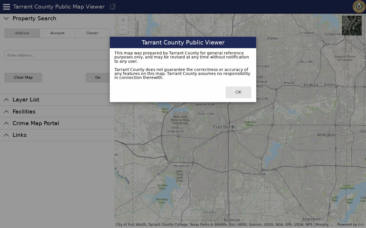
The Address, Account, and Owner tabs shown in the map viewer are useful entry points, but a map position alone does not establish a household relationship. Pair the map result with TAD and the County Clerk record.
For a recent construction or site change, Arlington's permit GIS layer adds address, declared construction valuation, main use, land-use description, structure, and PROPGISID1 fields. It documents a project or permit relationship. Call a named person or entity a permittee, contractor, registrant, or party when that is what the source establishes.
Tarrant Deeds for Arlington Streets
The County Clerk's Real Property search is the place to test title terms after the parcel work. Its term box accepts grantor or grantee, subdivision, document type, and document number. The recorded-date controls include From and To fields plus recent-date presets. Select Index Only for indexed material, or Index and Full Text OCR when the phrase may occur in an imaged document. OCR can search a phrase, while the index treats multiple words individually.
Use the Tarrant County Official Records Search with a subdivision or party term after TAD supplies a legal description.
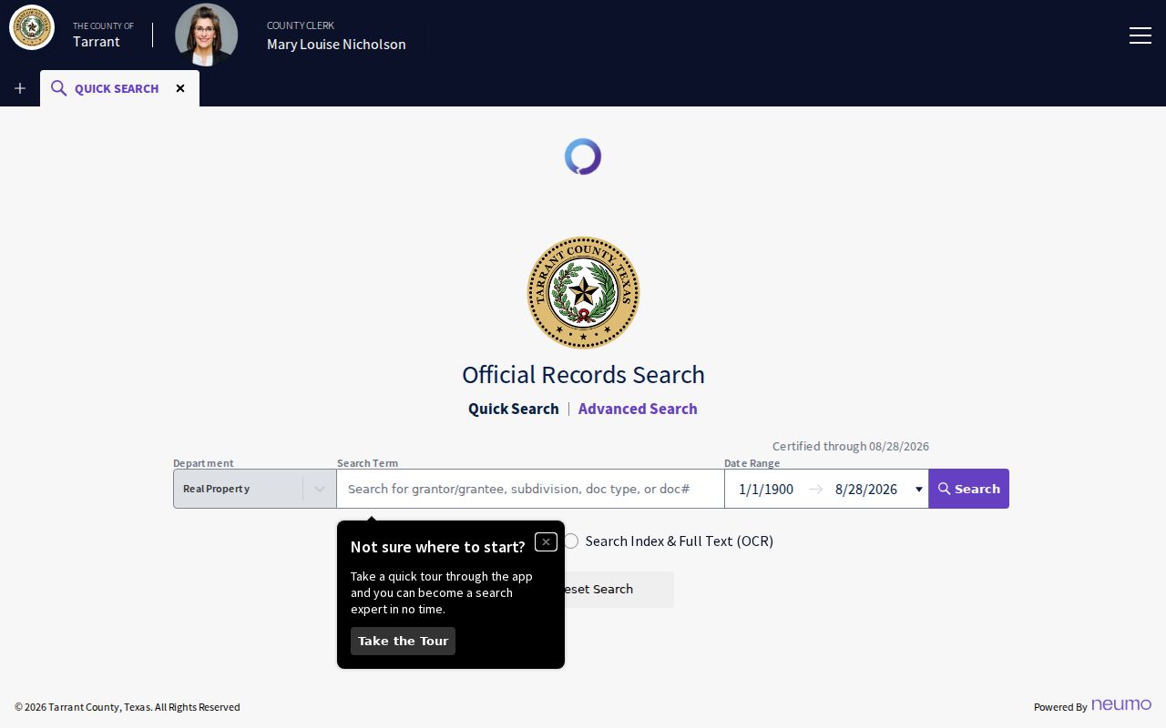
The captured search form shows the Real Property department, date controls, presets, and the Index Only and Index and Full Text OCR choices. A result row can identify record date, document number and type, grantor, grantee, subdivision or legal description, image or copy access, and a redaction notice. It records an instrument relationship, not a continuous history of who was present at the street address.
The portal displayed a certified-through date of August 28, 2026 during research. That is a current certification notice, not an advertised earliest online-coverage year. When the online search stops short, the County Clerk's real-estate office, historical ledgers, microfilm grantor-grantee material, and Archives assistance are the fallback chain.
Arlington Tax Cards: 1876 to 1984
Tarrant's separate deed-history card resource is a practical bridge for older Arlington parcels. The county says the cards support ownership and property history from 1876 through 1984. Search either by subdivision name, subdivision code, block number, and lot group, or by abstract number and grantee. This is a historical property tool, not a substitute for the modern grantor-grantee index.
Its syntax matters. A subdivision search returns all blocks, an exact subdivision code is required, and a TARRANT prefix finds subdivision names beginning with that word. Do not include the leading A in an abstract number. For a grantee, enter LAST, FIRST; a partial surname returns names beginning with the entered text. These rules can turn an empty result into a useful card trail.
Note: The tax-card range identifies a historical aid, not a promise that every transfer or address change appears on one card.
Arlington Streets With Old Names
An old directory line can be right even when its street label no longer appears in a current map. Arlington's street code ties official names and map references to the 1955 Freese/Nichols map, while later changes require a date-sensitive search. South Center Street between Arbrook Boulevard and Southeast Green Oaks Boulevard became Dr. Martin Luther King Jr. Drive effective September 1, 2021. Search both forms when records fall on either side of that change.
UTA-area research has another local shift. Campus Drive and part of Monroe Street became S.W. and S. Nedderman Drive effective November 1, 1991. A street name can also sit near a municipal or postal boundary, so retain the original city, ZIP, and year from every historical entry. The exact wording in a deed or directory is evidence worth preserving, not a typo to erase.
Arlington Street Directory History
The 1913 copy of Arlington's original town plat is a useful bridge between original lots and later street addresses. The UTA Arlington Land Records collection holds original-town abstracts, title reports, deeds, surveys, and plats. Its subdivision material includes Harrison, Iondale Place, Oak Hill Acres, Oak Park, Parkview, Pilant Acres, and Summit Grove. These are research terms for an old legal description, not proof of a person at a location.
For a changed street, add the 1917 Sanborn map sheets, newspaper OCR, and UTA image collections after the legal description is stable. Sanborn sheets can place a building and block in time, but they are not resident lists. The Arlington Public Library partner collection and the Arlington Journal can add a dated name or address mention that should be checked against the original scan.
Arlington Street Directory Coverage
Address-keyed sources answer different questions. Use the record date and the field label before joining results. Current parcel data can anchor a legal description; a deed can document a recorded transaction; a tax card can help with an older ownership trail; a directory can show a dated listing. The table separates these roles so a street search does not turn a fragment into a claim about every person on the road.
| Address source | Custodian | What it can show | Access route |
|---|---|---|---|
| Parcel and appraisal card | Tarrant Appraisal District | Address, account, owner field, mailing field, legal description, and georeference | Online TAD search |
| Parcel and civic layers | Tarrant GIS and CAID | Spatial relationship to property, ZIP, precinct, schools, and facilities | Online map viewer |
| Recorded instruments | Tarrant County Clerk | Grantor, grantee, date, document type or number, and legal-description terms | Official Records Search, Clerk access |
| Deed-history cards | Tarrant County Tax | Historic property and ownership trail, 1876 to 1984 | Online deed-card search |
| Dated listings | TSL, Tarrant Archives, and UT catalog | Telephone subscriber or directory listing at a date | Library, Archives, or catalog route |
| Permit layer | City of Arlington GIS | Permit and project context by address | City permit GIS layer |
Texas State Library holdings include Arlington issues for 1960 to 1961, 1966 to 1967, 1969 to 1979, 1981 to 1982, 1984, 1985 to 1986, and 1987. Tarrant Archives Polk volumes include 1979, 1982, and 1984 to 1988. The UT telephone-directory catalog runs from 1907 to 2002 with gaps. For the historical shelf and how to read an entry, use the Arlington city directory rather than treating a single listing as title evidence.
Arlington Street Records Access
Not every Arlington street record has the same online path. TAD and the County GIS provide current parcel and map context. Official Records Search provides a current index with a certified-through notice, while older material is split among deed cards, historic land ledgers, directories, library collections, and special collections. An empty web search can mean a different vocabulary, a coverage gap, or a record held by another custodian.
The Tarrant County Archives holds historic ledgers, directories, maps, cemetery records, property and land material, and can assist with a more detailed court and property list. Its facility is at 200 Taylor Street, Suite 5200, Fort Worth. For a plat question, Arlington also provides plat search and a City Hall Map Room route. Use the counter, archive, or map-room route when a portal does not expose the needed era or field.
Arlington Street Directory Limits
A street search cannot disclose everything about a household. Utility customer data and DMV address data are not open through a general public-record request. Texas Address Confidentiality Program participants use a substitute address and mail forwarding, and their actual residence should not be exposed through the voter system. Court, vital, juvenile, sealed, expunged, adoption, and protected voter information also carry their own limits.
Use plain evidence labels. An owner field names an owner of record, a directory entry names a listed occupant or subscriber, a permit record identifies a permittee, and a deed identifies a party. If a source does not establish residence, say what it does establish and verify material findings with the office that maintains the record.
Note: Texas Penal Code Chapter 42 addresses stalking and harassment, and public availability does not excuse harmful downstream use.